

Rating System
Fire-Ed Up Scenario 2:
Welcome to the Australian Fire Danger Rating System supplementary page for the Stage 5 iSTEM, Fire-Ed Up Unit of Work. This is a resource site setup to support teachers to implement the Fire-Ed Up Program.
Fire-Ed Up is funded by the NSW Office of the Chief Scientist and Engineer, developed from Central Coast Council’s Award Winning program and produced by the Hunter Innovation and Science Hub.
Scenario Background –
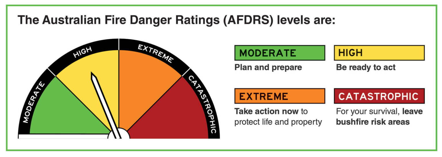
Australian Fire Danger Rating System
In 2022 Australia introduced a new fire danger rating system providing clearer and more accurate information to communities at risk of bush fire. The Australian Fire Danger Rating System brings together the latest science and knowledge of fire behaviour, is supported by extensive community research, and is the most significant change to the fire danger rating system in more than 50 years.
The previous fire danger rating system was found to be approximately 40% accurate whilst the new reporting system is now more than 60%, but there is room for improvement.
Scenario
Utilising STEM technologies and local environmental insights to enhance your community’s bush fire danger rating system.
Field Measurements:
Embarking on Fire Researcher
In a manner akin to professional fire authorities in Australia, we are embarking on a journey to become field researchers. Our objective is to collect critical data from natural environments to enhance our understanding of bushfire risks in our vicinity.
Your Role as a Field Researcher
Emulate the expertise of these professionals. Utilising precise measuring instruments and meticulous observation, your task is to gather essential data that will aid in forecasting a simulated local Fire Behaviour Index (FBI) and Australian Fire Danger Ratings (AFDR).
Data Collection Parameters
- Temperature: Measure the outdoor temperature. High heat is a significant factor in fire behavior.
- Wind Speed: Assess how strong winds might escalate fire intensity.
- Humidity: Evaluate air dryness, as low humidity leads to faster burning of dry vegetation.
- Fuel Load: Quantify the potential combustible material in a given area.
- Fuel Moisture Content: Determine the dryness of the fuel, affecting its flammability.
- Land Slope: Observe the terrain steepness, which influences fire spread speed.
- Vegetation Type: Identify and categorize the vegetation, understanding the varying combustion characteristics of different plant types.
Field Locations
Your research may occur at our school grounds, a nearby field, or another relevant location. Stay observant and ensure your measuring tools are always at hand.
Application of Gathered Data
Upon gathering this data, we will utilise it later in our program to simulate the local FBI and AFDR. Effectively, we will be creating a miniature fire forecast system within our educational setting.
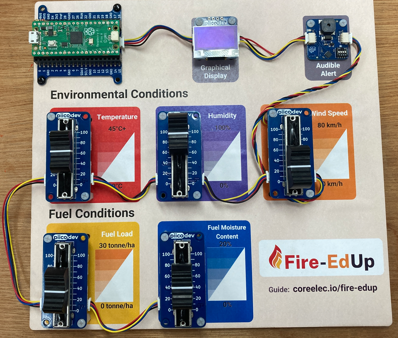
Digital technologies
Gear up to use Raspberry Pi microcomputers to recreate and improve how we predict bushfires with the Australian fire danger rating system.
You’ll:
- Tweak the Code
Modify existing code to get better at predicting fires using local data. - Explore the tech
Discover how digital twins, satellites, and drones can help in bushfire safety.
You’ll become mini tech experts, using cool gadgets to make a difference in keeping our community safe from fires!
Downloadable Resources

iSTEM AFDRS – Student Resource Folio
Download the Fire-Ed Up Australian Fire Danger Rating System supplementary student resource folio.
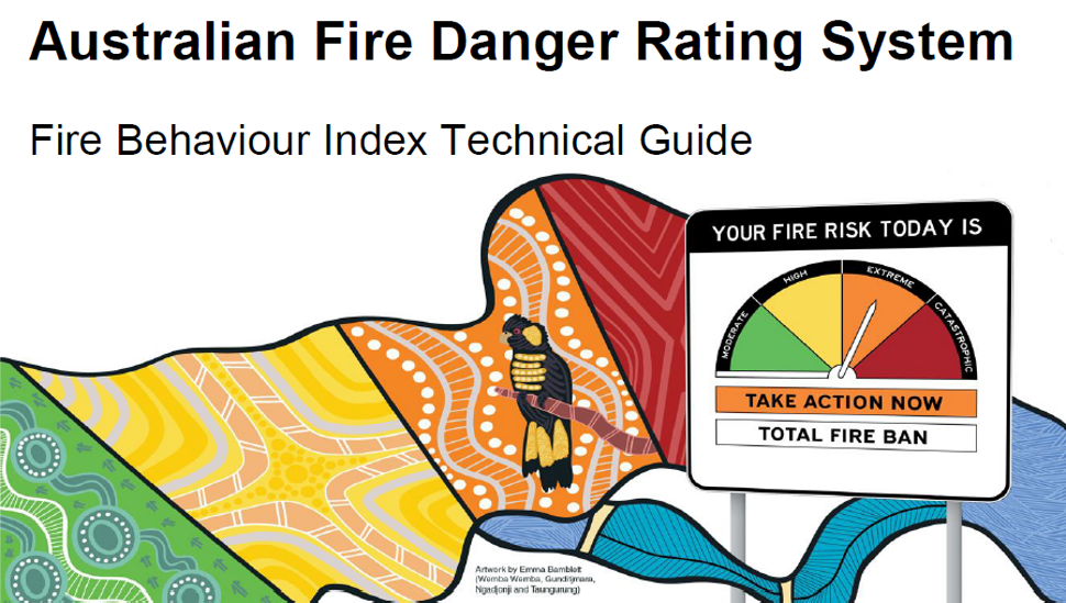
Australian Fire Danger Rating System
Australian fire danger rating system – Fire Behaviour Index Technical Guide V2.1 Oct 2023.
NSW RFS Firefighters Pocket Book
The NSW Rural Fire Service Firefighters Pocket Book Dec 2010 edition.
Grassland Curing Guide
The grassland curing guide from the Country Fire Authority CFA Victoria.
Video Based Resources
The following are a mixture of Fire-ED Up original video resources and others that you might find useful.
Unpacking the Fire Danger Rating System
Dr David Clarke, Fire Behaviour Analyst at the NSW Rural Fire Service explains the science behind the AFDRS (14:53 minutes)
Why the Fire Danger Rating System was updated?
Dr Meaghan Jenkins, AFDRS Manager at the NSW Rural Fire Service discusses the reasons for the update of the AFDRS (14:03 minutes)
Fire 101 – Ben Newsome Fizzics Education
Ben Newsome from Fizzics Education demonstrates some scientific experiments that explain the basics of fire and a fun and educational video. (15:27 minutes)
About AFAC
Sandra Whight – A/Director National Projects and Innovation at AFAC explains the work done by AFAC in bushfire management (11:01 minutes)
How to use an Anemometer (Kestral)
How to use a Kestral to measure wind speed, humidity and temperature, thanks to Rumbalara Environmental Education Centre (0:45 minutes)
How to use a clinometer
How to use a clinometer to determine the slope of the land, thanks to Rumbalara Environmental Education Centre (0:15 minutes)
Other Resources
Websites
Australian Fire Danger Rating System
https://afdrs.com.au/
Core Electronics Fire-Ed Up Guide
coreele.io/Fire-edup
NSW RFS – Fires Near Me Website
https://www.rfs.nsw.gov.au/fire-information/fires-near-me
Bushfire Prepare WA Government
https://www.dfes.wa.gov.au/hazard-information/bushfire/prepare
CSIRO Guide to rate of fire spread models for Australian Vegetation
https://research.csiro.au/firemodelsguide/
Australian Bureau of Meteorology
http://www.bom.gov.au/
NSW Rural Fire Service – Neighbourhood Safer Places
https://www.rfs.nsw.gov.au/plan-and-prepare/neighbourhood-safer-places
NSW Department of Education – Bushfire and Grassfire Risk Ratings Categories
https://education.nsw.gov.au/inside-the-department/health-and-safety/emergency-planning-and-incident-response/emergency-management-procedures/bushfire-planning#/asset1
Mindtools – Brainstorming
https://www.mindtools.com/acv0de1/brainstorming
Other Resources
Bushfire Survival
Online RFS Bushfire Survival plan
https://www.myfireplan.com.au/
Bushfire Survival Plan PDF version
https://www.rfs.nsw.gov.au/__data/assets/pdf_file/0017/2933/BushFireSurvivalPlan.pdf
Apps
NSW RFS Firefighter Pocketbook – Android
https://play.google.com/store/apps/details?id=com.tiltandco.pocketguide&hl=en_AU&gl=US
NSW RFS Firefighter Pocketbook – IOS
https://apps.apple.com/au/app/nsw-rfs-firefighter-pocketbook/id872370884
Hazards Near Me – Android
https://play.google.com/store/apps/details?id=au.gov.nsw.rfs.firesnearme.nsw
Hazards Near Me – IOS
https://apps.apple.com/au/app/hazards-near-me-nsw/id370891827
Satellites
Himawari-8 Satellite Viewer Introduction Video
https://www.youtube.com/watch?v=mODSZFIYVqk
Australian Bureau of Meteorology’s Satellite Viewer Site
http://satview.bom.gov.au/
Software
Spatial Information eXchange
https://maps.six.nsw.gov.au/
NSW Department of Education – Digital Learning Selector
https://app.education.nsw.gov.au/digital-learning-selector/?cache_id=e6c80